World Heritage in the Carpathians

The World Heritage List includes 851 properties forming part of the cultural and natural heritage which the World Heritage Committee considers as having outstanding universal value.
These include 660 cultural, 166 natural and 25 mixed properties in 184 States Parties.
In Carpathian Mountains and in their immediate vicinity there are over 20 properties.
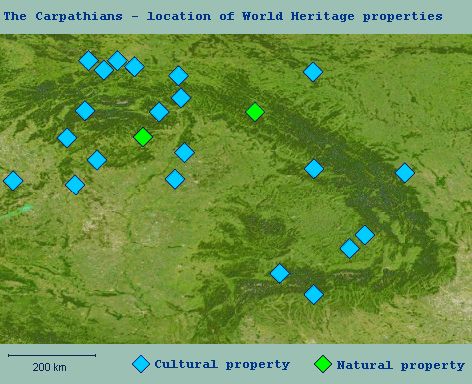
Table of Contents
 The Criteria for Selection The Criteria for Selection
To be included on the World Heritage List, sites must be of outstanding universal value and meet at least one out of ten selection criteria. These criteria are explained in the Operational Guidelines for the Implementation of the World Heritage Convention which, besides the text of the Convention, is the main working tool on World Heritage. The criteria are regularly revised by the Committee to reflect the evolution of the World Heritage concept itself.
Until the end of 2004, World Heritage sites were selected on the basis of six cultural and four natural criteria. With the adoption of the revised Operational Guidelines for the Implementation of the World Heritage Convention, only one set of ten criteria exists.
| |
Cultural criteria |
|
Natural criteria |
| Operational Guidelines 2002 |
(i) |
(ii) |
(iii) |
(iv) |
(v) |
(vi) |
|
(i) |
(ii) |
(iii) |
(iv) |
| Operational Guidelines 2005 |
(i) |
(ii) |
(iii) |
(iv) |
(v) |
(vi) |
|
(viii) |
(ix) |
(vii) |
(x) |
Selection criteria:
- to represent a masterpiece of human creative genius;
- to exhibit an important interchange of human values, over a span of time or within a cultural area of the world, on developments in architecture or technology, monumental arts, town-planning or landscape design;
- to bear a unique or at least exceptional testimony to a cultural tradition or to a civilization which is living or which has disappeared;
- to be an outstanding example of a type of building, architectural or technological ensemble or landscape which illustrates (a) significant stage(s) in human history;
- to be an outstanding example of a traditional human settlement, land-use, or sea-use which is representative of a culture (or cultures), or human interaction with the environment especially when it has become vulnerable under the impact of irreversible change;
- to be directly or tangibly associated with events or living traditions, with ideas, or with beliefs, with artistic and literary works of outstanding universal significance. (The Committee considers that this criterion should preferably be used in conjunction with other criteria);
- to contain superlative natural phenomena or areas of exceptional natural beauty and aesthetic importance;
- to be outstanding examples representing major stages of earth's history, including the record of life, significant on-going geological processes in the development of landforms, or significant geomorphic or physiographic features;
- to be outstanding examples representing significant on-going ecological and biological processes in the evolution and development of terrestrial, fresh water, coastal and marine ecosystems and communities of plants and animals;
- to contain the most important and significant natural habitats for in-situ conservation of biological diversity, including those containing threatened species of outstanding universal value from the point of view of science or conservation.
The protection, management, authenticity and integrity of properties are also important considerations.
Since 1992 significant interactions between people and the natural environment have been recognized as cultural landscapes.
The Carpatians - World Heritage properties
Hungary
- Millenary Benedictine Abbey of Pannonhalma and its Natural Environment
 • County of Györ-Moson-Sopron
• Date of inscription: 1996
 • Criteria: C (iv) (vi)
• Identification No. 758
The first Benedictine monks settled here in 996. They went on to convert the Hungarians, to found the country's first school and, in 1055, to write the first document in Hungarian. From the time of its founding, this monastic community has promoted culture throughout central Europe. Its 1,000-year history can be seen in the succession of architectural styles of the monastic buildings (the oldest dating from 1224), which still today house a school and the monastic community.
- Budapest, including the Banks of the Danube, the Buda Castle Quarter and Andrássy Avenue
• Multiple locations
• Date of inscription: 1987, extension: 2002
• Criteria: C (ii) (iv)
• Identification No. 400
This site has the remains of monuments such as the Roman city of Aquincum and the Gothic castle of Buda, which have had a considerable influence on the architecture of various periods. It is one of the world's outstanding urban landscapes and illustrates the great periods in the history of the Hungarian capital.
| ID No. |
Name |
Locations |
| 400-001 |
Budapest, the Banks of the Danube and the Buda Castle Quarter |
Budapest |
| 400-002 |
Andrássy Avenue and the Underground |
Budapest |
|
- Old Village of Hollókö and its Surroundings
• County of Nógrád
• Date of inscription: 1987
• Criteria: C (v)
• Identification No. 401
Hollókö is an outstanding example of a deliberately preserved traditional settlement. This village, which developed mainly during the 17th and 18th centuries, is a living example of rural life before the agricultural revolution of the 20th century.
-
Hortobágy National Park - the Puszta
• Counties of Borsod-Abaúj-Zemplén, Heves, Hajdú-Bihar
and Jász-Nagykun-Szolnok
• Date of inscription: 1999
• Criteria: C (iv) (v)
• Identification No. 474
The cultural landscape of the Hortobágy Puszta consists of a vast area of plains and wetlands in eastern Hungary. Traditional forms of land use, such as the grazing of domestic animals, have been present in this pastoral society for more than two millennia.
- Tokaj Wine Region Historic Cultural Landscape
• County of Borsod-Abaúj-Zemplén
• Multiple locations
• Date of inscription: 2002
• Criteria: C (iii) (v)
• Identification No. 1063
The cultural landscape of Tokaj graphically demonstrates the long tradition of wine production in this region of low hills and river valleys. The intricate pattern of vineyards, farms, villages and small towns, with their historic networks of deep wine cellars, illustrates every facet of the production of the famous Tokaj wines, the quality and management of which have been strictly regulated for nearly three centuries.
| ID No. |
Name |
Location |
Area (ha) |
| 1063-001 |
Tokaj Wine Region |
settlements of Tokaj, Tarcal, Bodrogkeresztúr, Mád, Tállya |
13,425.00 |
| 1063-002 |
Ungvári Wine Cellar |
Sátoraljaújhely |
4.00 |
| 1063-003 |
Rákóczi Wine Cellar |
Sárospatak |
0.80 |
| 1063-004 |
Köporosi Cellars |
Hercegkút |
1.70 |
| 1063-005 |
Gomboshegyi Cellars |
Hercegkút |
2.00 |
| 1063-006 |
Oremus Cellars |
Tolcsva |
0.90 |
| 1063-007 |
Tolcsva Wine Museum Cellars |
Tolcsva |
0.60 |
|
Hungary / Slovakia
- Caves of Aggtelek Karst and Slovak Karst
• County of Borsod-Abaúj-Zemplén (HU) / Districts of
Rožňava and Spišska Nová Ves, Region of Košice (SK)
• Multiple locations
• Date of inscription: 1995, extension: 2000
• Criteria: N (i)
• Identification No. 725
The variety of formations and the fact that they are concentrated in a restricted area means that the 712 caves currently identified make up a typical temperate-zone karstic system. Because they display an extremely rare combination of tropical and glacial climatic effects, they make it possible to study geological history over tens of millions of years.
| ID No. |
Name |
Locations |
| 725-001 |
Baradla-Domica Cave System |
Aggtelek-Jósvafő Settlement |
| 725-002 |
Béke-barlang Cave |
Aggtelek-Jósvafő Settlement |
| 725-003 |
Kossuth-barlang Cave |
Jósvafő (village) |
| 725-004 |
Meteor-barlang Cave |
Village of Bódvaszilas |
| 725-005 |
Rákóczi 1.sz. barlang Cave |
Bodvarákó (village) |
| 725-006 |
Rákóczi 2.sz,.barlang Cave |
settlement Bodvarákó |
| 725-007 |
Rejtek-szomboly Chasm |
settlement Szögliget |
| 725-008 |
Szabadság-barlang Cave |
Égerszög village |
| 725-009 |
Vass Imre-barlang Cave |
Jósvafő Settlement |
| 725-010 |
Vecsem-bükki-szomboly Chasm |
Bódvaszilas |
| 725-011 |
Baradla-Domica Cave System |
Kečovo, Rožňava district |
| 725-012 |
Diviačia Chasm |
Plešivec, Rožňava district |
| 725-013 |
Drienovska Cave |
Drienovec, Košice-country district |
| 725-014 |
Gombasecká Cave-Silicka ľadnica Ice Cave System |
Slavec, Rožňava district |
| 725-015 |
Hrušovska Cave |
Hrušov, Rožňava district |
| 725-016 |
Jasovska Cave |
Jasov, Košice-country district |
| 725-017 |
Krásnohorská Cave |
Krásnohorská Dlhá Lúka, Rožňava district |
| 725-018 |
Ochtinská aragonitová Cave |
Ochtiná, Rožňava district |
| 725-019 |
Obrovská Chasm |
Jablonov nad Turňou |
| 725-020 |
System of the Skalistý potok Cave-Kunia Chasm |
Háj |
| 725-021 |
Snežná diera Cave |
Bôrka |
| 725-022 |
Zvonivá diera Chasm |
Plešivec |
| 725-023 |
Dobšinská Ice Cave |
Spišska Nová Ves, Poprad, Rožňava |
|
Slovakia
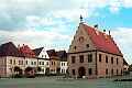
- Banská Štiavnica
• Town and District of Banská Štiavnica,
Region of Banská Bystrica
• Date of inscription: 1993
• Criteria: C (iv) (v)
• Identification No. 618
Over the centuries, the town of Banská Štiavnica was visited by many outstanding engineers and scientists, many of whom contributed to its fame. The old medieval mining centre grew into a town with Renaissance palaces, 16th-century churches, elegant squares and castles. The urban centre blends into the surrounding landscape, which contains vital relics of the mining and metallurgical activities of the past.
- Vlkolínec
• Ružomberok District,
Žilina Region
• Date of inscription: 1993
• Criteria: C (iv) (v)
• Identification No. 622
Vlkolínec, situated in the centre of Slovakia, is a remarkably intact settlement of 45 buildings with the traditional features of a central European village. It is the region's most complete group of these kinds of traditional log houses, often found in mountainous areas.
- Spišský Hrad and its Associated Cultural Monuments
• Town of Spišské Podhradie, Levoča District,
Prešov Region
• Date of inscription: 1993
• Criteria: C (iv)
• Identification No. 620
Spišský Hrad has one of the largest ensembles of 13th- and 14th-century military, political and religious vbuildings in eastern Europe, and its Romanesque and Gothic architecture has remained remarkably intact.
- Bardejov Town Conservation Reserve
• Town and District of Bardejov,
Prešov Region
• Date of inscription: 2000
• Criteria: C (iii) (iv)
• Identification No. 973
Bardejov is a small but exceptionally complete and well-preserved example of a fortified medieval town, which typifies the urbanisation in this region. Among other remarkable features, it also contains a small Jewish quarter around a fine 18th-century synagogue.
Poland
- Auschwitz Birkenau
German Nazi Concentration and Extermination Camp (1940-1945)
• Oświęcim County,
Lesser Poland (Małopolska) Voivodship
• Multiple locations
• Date of inscription: 1979
• Criteria: C (vi)
• Identification No. 31
The fortified walls, barbed wire, platforms, barracks, gallows, gas chambers and cremation ovens show the conditions within which the Nazi genocide took place in the former concentration and extermination camp of Auschwitz-Birkenau, the largest in the Third Reich. According to historical investigations, 1.5 million people, among them a great number of Jews, were systematically starved, tortured and murdered in this camp, the symbol of humanity's cruelty to its fellow human beings in the 20th century.
| ID No. |
Name |
| 31-001 |
Auschwitz |
| 31-002 |
Birkenau |
|
- Kalwaria Zebrzydowska: the Mannerist Architectural and Park Landscape Complex and Pilgrimage Park
• Lesser Poland (Małopolska) Voivodship
• Date of inscription: 1999
• Criteria: C (ii) (iv)
• Identification No. 905
Kalwaria Zebrzydowska is a breathtaking cultural landscape of great spiritual significance. Its natural setting – in which a series of symbolic places of worship relating to the Passion of Jesus Christ and the life of the Virgin Mary was laid out at the beginning of the 17th century – has remained virtually unchanged. It is still today a place of pilgrimage.
- Cracow's Historic Centre
• City and County of Cracow,
Lesser Poland (Małopolska) Voivodship
• Date of inscription: 1978
• Criteria: C (iv)
• Identification No. 29
The historic centre of Cracow, the former capital of Poland, is situated at the foot of the Royal Wawel Castle. The 13th-century merchants' town has Europe's largest market square and numerous historical houses, palaces and churches with their magnificent interiors. Further evidence of the town's fascinating history is provided by the remnants of the 14th-century fortifications and the medieval site of Kazimierz with its ancient synagogues in the southern part of town, Jagellonian University and the Gothic cathedral where the kings of Poland were buried.
- Wieliczka Salt Mine
• City and County of Wieliczka,
Lesser Poland (Małopolska) Voivodship
• Date of inscription: 1978
• Criteria: C (iv)
• Identification No. 32
This deposit of rock salt in Wieliczka-Bochnia has been mined since the 13th century. Spread over nine levels, it has 300 km of galleries with works of art, altars, and statues sculpted in the salt, making a fascinating pilgrimage into the past of a major industrial undertaking.
- Wooden Churches of Southern Little Poland
• Gorlice, Nowy Targ, and Bochnia counties, Lesser
Poland (Małopolska) Voivodship; Brzozów County,
Subcarpathian (Podkarpackie) Voivodship
• Multiple locations
• Date of inscription: 2003
• Criteria: C (iii) (iv)
• Identification No. 1053
The wooden churches of southern Little Poland represent outstanding examples of the different aspects of medieval church-building traditions in Roman Catholic culture. Built using the horizontal log technique, common in eastern and northern Europe since the Middle Ages, these churches were sponsored by noble families and became status symbols. They offered an alternative to the stone structures erected in urban centres.
| ID No. |
Name |
Location |
Date |
Area (ha) |
| 1053-001 |
Church of the Archangel Michael |
Binarowa |
c. 1500 |
1.80 |
| 1053-002 |
Church of All Saints |
Blizne |
mid 15th c |
2.20 |
| 1053-003 |
Church of the Archangel Michael |
Dębno |
2nd half 15th c |
0.14 |
| 1053-004 |
Church of the Assumption of the Blessed Virgin Mary and the Archangel Michael |
Haczów |
mid 15th c |
1.30 |
| 1053-005 |
Church of St Leonard |
Lipnica Murowana |
late 15th c |
1.10 |
| 1053-006 |
Church of St Philip and St James the Apostles |
Sękowa |
1516 |
1.72 |
|
Ukraine
- L'viv - the Ensemble of the Historic Centre
• Halychyna, L'viv Oblast'
• Multiple locations
• Date of inscription: 1998
• Criteria: C (ii) (v)
• Identification No. 865
The city of L'viv, founded in the late Middle Ages, was a flourishing administrative, religious and commercial centre for several centuries. The medieval urban topography has been preserved virtually intact (in particular, there is evidence of the different ethnic communities who lived there), along with many fine Baroque and later buildings.
| ID No. |
Name |
| 865-001 |
Vysokyi Zamok and Pidzamche, Seredmistia |
| 865-002 |
Ensemble of St.Yuri - the Dragonfighter Church |
|
Slovakia / Ukraine
- Primeval Beech Forests of the Carpathians
• Region of Prešov (SK) / Transcarpathian (UE)
• Multiple locations
• Date of inscription: 2007
• Criteria: N (ix)
• Identification No. 1133
The Primeval Beech Forests of the Carpathian constitute a transnational serial property of ten separate components along a 185 km axis from the Rakhiv Mountains and the Chornohirskyi Range in Ukraine, west along the Polonynian Ridge, to the Bukovské Vrchy and Vihorlat Mountains in Slovakia. The ten sites represent an outstanding example of undisturbed, complex temperate forests and exhibit the most complete and comprehensive ecological patterns and processes of pure stands of European beech across a variety of environmental conditions. They contain an invaluable genetic reservoir of beech and many species associated with, and dependent on, these forest habitats. They also represent an outstanding example of the re-colonization and development of terrestrial ecosystems and communities after the last ice age, a process which is still ongoing.
| ID No. |
Name & Location |
Area (ha) |
| 1133-001 |
Chornohora
Transcarpathian |
Core zone: 2476.8
Buffer zone: 12925 |
| 1133-002 |
Havešová Primeval Forest
Transcarpathian |
Core zone: 171.3
Buffer zone: 63.99 |
| 1133-003 |
Kuziy-Trybushany
Prešov |
Core zone: 1369.6
Buffer zone: 3163.4 |
| 1133-004 |
Maramarosh
Transcarpathian |
Core zone: 2243.6
Buffer zone: 6230.4 |
| 1133-005 |
Rožok
Prešov |
Core zone: 67.1
Buffer zone: 41.4 |
| 1133-006 |
Stužnica - Bukovské Vrchy
Prešov |
Core zone: 2950
Buffer zone: 11300 |
| 1133-007 |
Stuzhytsia - Uzhok
Transcarpathian, |
Core zone: 2532
Buffer zone: 3615 |
| 1133-008 |
Svydovets
Transcarpathian |
Core zone: 3030.5
Buffer zone: 5639.5 |
| 1133-009 |
Uholka - Shyrikyi Luh
Transcarpathian, |
Core zone: 11860
Buffer zone: 3301 |
| 1133-010 |
Vihorlat
Prešov |
Core zone: 2578
Buffer zone: 2413 |
|
Romania
- Wooden Churches of Maramureş
• Districts of Bârsana, Budeşti, Deseşti, Ieud, Şişeşti,
Poienile Izei, Târgu-Lăpuş; Maramureş County,
Region of Transylvania.
• Multiple locations
• Date of inscription: 1999
• Criteria: C (iv)
• Identification No. 904
These eight churches are outstanding examples of a range of architectural solutions from different periods and areas. They show the variety of designs and craftsmanship adopted in these narrow, high, timber constructions with their characteristic tall, slim clock towers at the western end of the building, either single- or double-roofed and covered by shingles. As such, they are a particular vernacular expression of the cultural landscape of this mountainous area of northern Romania.
| Church |
Date |
District |
Village |
| The Church of the Presentation of the Virgin at the Temple |
1720 |
Bârsana |
Bârsana |
| The Church of Saint Nicholas |
1643 |
Budeşti |
Budeşti |
| The Church of the Holy Paraskeva |
1770 |
Deseşti |
Deseşti |
| The Church of the Nativity of the Virgin |
mid 18th c |
Ieud |
Ieud |
| The Church of the Holy Archangels |
1796-8 |
Şişeşti |
Plopiş |
| The Church of the Holy Parasceve |
1604 |
Poienile Izei |
Poienile Izei |
| The Church of the Holy Archangels |
1663 |
Târgu-Lăpuş |
Rogoz |
| The Church of the Holy Archangels |
1767 |
Şişeşti |
Şurdeşti |
|
- Churches of Moldavia
• County of Suceava, Region of Moldavia
• Multiple locations
• Date of inscription: 1993
• Criteria: C (i) (iv)
• Identification No. 598
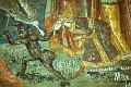
With their painted exterior walls, decorated with 15th- and 16th-century frescoes that are considered masterpieces of Byzantine art, these seven churches in northern Moldavia are unique in Europe. Far from being merely wall decorations, the paintings represent complete cycles of religious murals on all facades. Their outstanding composition, elegant outline and harmonious colours blend perfectly with the surrounding landscape.
| ID No. |
Date |
Name |
Village |
| 598-001 |
1503 |
Church of the Beheading of St John the Baptist, Arbore |
Abore |
| 598-002 |
1530 |
Church of the Assumption of the Virgin of the former Monastery of Humor |
Humor |
| 598-003 |
1532 |
Church of the Annunciation of the Monastery of Moldoviţa |
Moldoviţa |
| 598-004 |
1487 |
Church of the Holy Rood, Pătrăuţi |
Pătrăuţi |
| 598-005 |
1531 |
Church of St Nicholas and the Catholicon of the Monastery of Probota |
Probota |
| 598-006 |
1522 |
Church of St George, Suceava |
Suceava |
| 598-007 |
1487 |
Church of St George of the former Voroneţ Monastery |
Voroneţ |
|
- Historic Centre of Sighişoara
• Mureş County,
Region of Transylvania
• Date of inscription: 1999
• Criteria: C (iii) (v)
• Identification No. 902
Founded by German craftsmen and merchants known as the Saxons of Transylvania, Sighişoara is a fine example of a small, fortified medieval town which played an important strategic and commercial role on the fringes of central Europe for several centuries.
- Villages with Fortified Churches in Transylvania
• Counties of Alba, Braşov, Harghita, Mureş, Sibiu,
Region of Transylvania
• Multiple locations
• Date of inscription: 1993 ("Biertan and its Fortified Church"),
extension: 1999
• Criteria: C (iv)
• Identification No. 596
These Transylvanian villages with their fortified churches provide a vivid picture of the cultural landscape of southern Transylvania. The seven villages inscribed, founded by the Transylvanian Saxons, are characterized by a specific land-use system, settlement pattern and organization of the family farmstead that have been preserved since the late Middle Ages. They are dominated by their fortified churches, which illustrate building styles from the 13th to the 16th century.
| ID No. |
Village |
District |
Department |
| 596-001 |
Biertan |
Biertan |
Sibiu |
| 596-002 |
Prejmer |
Prejmer |
Braşov |
| 596-003 |
Viscri |
Buneşti |
Braşov |
| 596-004 |
Dârjiu |
Dârjiu |
Harghita |
| 596-005 |
Saschiz |
Saschiz |
Mureş |
| 596-006 |
Câlnic |
Câlnic |
Alba |
| 596-007 |
Valea Viilor |
Valea Viilor |
Sibiu |
|
- Monastery of Horezu
• Vâlcea County,
Region of Wallachia
• Date of inscription: 1993
• Criteria: C (ii)
• Identification No. 597
Founded in 1690 by Prince Constantine Brancovan, the monastery of Horezu, in Wallachia, is a masterpiece of the 'Brancovan' style. It is known for its architectural purity and balance, the richness of its sculptural detail, the treatment of its religious compositions, its votive portraits and its painted decorative works. The school of mural and icon painting established at the monastery in the 18th century was famous throughout the Balkan region.
- Dacian Fortresses of the Orăştie Mountains
• Counties of Alba and Hunedoara,
Region of Transylvania
• Multiple locations
• Date of inscription: 1999
• Criteria: C (ii) (iii) (iv)
• Identification No. 906
Built in the 1st centuries B.C. and A.D. under Dacian rule, these fortresses show an unusual fusion of military and religious architectural techniques and concepts from the classical world and the late European Iron Age. The six defensive works, the nucleus of the Dacian Kingdom, were conquered by the Romans at the beginning of the 2nd century A.D.; their extensive and well-preserved remains stand in spectacular natural surroundings and give a dramatic picture of a vigorous and innovative civilization.
| ID No. |
Fortress |
Village |
Commune |
Department |
| 906-001 |
Sarmizegetusa |
Grădiştea de Munte |
Orăştioara de Sus |
Hunedoara |
| 906-002 |
Costeşti-Cetaţuie |
Costeşti |
Orăştioara de Sus |
Hunedoara |
| 906-003 |
Costeşti-Blidaru |
Costeşti |
Orăştioara |
Hunedoara |
| 906-004 |
Luncani-Piatra Roşie |
Luncani |
Boşorod |
Hunedoara |
| 906-005 |
Băniţa |
Băniţa |
Petroşani Municipality |
Hunedoara |
| 906-006 |
Căpâlna |
Căpâlna |
Săsciori |
Alba |
|
|